
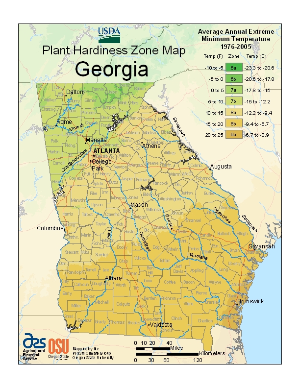
What’s My Growing Region?
Georgia has four growing regions: North Georgia (Regions 6 & 7), Central Georgia (Region 8a), South Georgia (Region 8b), and Coastal Georgia (Region 9a).
The two biggest factors in Georgia’s Climate are elevation and location to the coastline. We have broken the state into Growing Regions based upon the USDA Hardiness Zones, Geography, First/Last Frost Dates and our own Growing Experience. Please remember that Growing Region-Specific Planting Dates can be found on each Seed Listing!
North Georgia
North Georgia encompasses the USDA Hardiness Zones 6 & 7 (Please see the USDA Hardiness Zones Map). This section of the State contains the highest elevations, including mountains, and highlands.
The Goober State’s coldest temperatures, along with earliest and latest average Frost Dates can be found in North Georgia. The strictest growing calendar can be found in this region. North Georgia includes Blairsville, Helen, Dalton, and Trenton.
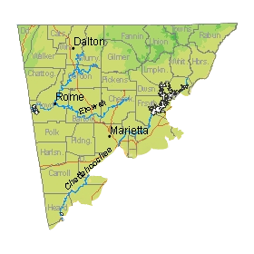
- Rabun County, Towns County, Union County, Fannin County, Murray County, Gilmer County, Whitfield County, Catoosa County, Walker County, Dade County, Chatooga County, Floyd County, Bartow County, Gordon County, Pickens County, Dawson County, Lumpkin County, White County, Habersham County, Cherokee County, Forsyth County, Hall County, Franklin County, Hart County, Polk County, Paulding County, Haralson County, Carroll County, Heard County, North Coweta County, West Fulton County, Cobb County, West Barrow County
| City | Average First Frost | Average Last Frost |
|---|---|---|
| Blairsville | October 16 | April 27 |
| Carrollton | November 3 | March 26 |
| Cedartown | November 4 | April 6 |
| Chatsworth | November 2 | April 7 |
| Cleveland | October 22 | April 15 |
| Cumming | November 1 | April 3 |
| Helen | October 28 | April 10 |
| Rome | November 5 | March 31 |
| Sautee | October 29 | April 15 |
| Summerville | October 24 | April 12 |
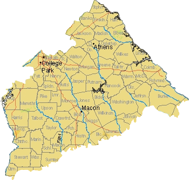
Central Georgia
Central Georgia encompasses the USDA Hardiness Zone 8a (Please see the USDA Hardiness Zones Map). This section of the State is known as the Piedmont because the land gradually slopes up, from the Lower Elevations of Southern Georgia, toward the Higher Elevations of the North. Central Georgia includes Atlanta, Athens, Macon, and Augusta.
| City | Average First Frost | Average Last Frost |
|---|---|---|
| Athens | November 8 | March 25 |
| Atlanta | November 18 | March 14 |
| Columbus | November 20 | March 4 |
| Macon | November 7 | March 24 |
| Plains | November 14 | March 23 |
| Warner Robins | November 18 | March 13 |
South Georgia
Southern Georgia encompasses the USDA Hardiness Zone 8b (Please see the USDA Hardiness Zones Map). This section of the State is known as a Coastal Plain because although it contains hills, it is mostly free of dramatic changes in elevation. In addition to flat land and hills, South Georgia contains marshes and swamps. Major cities located in South Georgia include Savannah, Albany, and Valdosta.

| City | Average First Frost | Average Last Frost |
|---|---|---|
| Albany | November 18 | March 10 |
| Blakely | November 19 | March 14 |
| Valdosta | November 20 | March 13 |
| Savannah | November 28 | March 6 |
Coastal Georgia
Coastal Georgia encompasses the USDA Hardiness Zone 9a (Please see the USDA Hardiness Zones Map). This section of the State is known for its marshes, inlets, and coastline. It’s proximity to the coast, provides Milder Winters in Coastal Georgia. Major cities in Coastal Georgia include Brunswick, St Mary’s, and Kingsland.
| City | Average First Frost | Average Last Frost |
|---|---|---|
| Brunswick | December 15 | February 15 |